The Seagrass Sentinel: Watching Over Our Ocean's Hidden Meadows from Space
The Seagrass Sentinel: Watching Over Our Ocean's Hidden Meadows from Space
When we think of coastal conservation, our minds often jump to vibrant coral reefs or towering mangrove forests. But just beneath the waves lies one of the most powerful, yet overlooked, ecosystems on our planet: seagrass meadows.
These vast underwater regions are quiet powerhouses. They support incredible biodiversity, regulate our climate, and protect our coastlines. But like many marine ecosystems, they are under serious threat.
At The Oceans Need Us (TONU), we believe you cannot protect what you cannot see. That's why we are excited to introduce our newest conservation tool: The Seagrass Sentinel, a live, AI-driven satellite monitoring dashboard designed to keep a close eye on these vital habitats.
Here's why seagrass matters, how we monitor it from space, and how you can explore the data yourself.
The Magic of Seagrass
Seagrasses are the only true flowering plants that live completely underwater. Found in shallow coastal waters across Australia and around the world, these extensive meadows offer a range of ecosystem services.
Blue Carbon Sinks: Seagrasses are excellent at capturing carbon. Despite covering less than 0.2% of the ocean floor, they hold up to 18% of the world’s oceanic carbon storage, storing it in their root systems for thousands of years.
Marine Nurseries: These meadows provide a safe refuge and abundant food for juvenile fish, crustaceans, and endangered marine species such as dugongs and green sea turtles.
Coastal Defence: Their extensive root systems act like anchors for the seafloor, preventing coastal erosion, while their leaves slow water flow and filter out sediments, keeping our oceans crystal clear.
The Invisible Threat
Despite their immense worth, we are losing seagrass meadows at a shocking rate, roughly a football field every 30 minutes worldwide. Coastal development, agricultural runoff, dredging, and warming ocean temperatures are causing this rapid decline.
Since seagrass grows underwater, its degradation often goes unnoticed until the damage becomes severe. Traditional field surveys, while extremely valuable, are costly, time-consuming, and limited in scope. We required a broader perspective.
Bridging the Gap: Science Meets Conservation
To effectively monitor and safeguard these ecosystems at scale, we require a comprehensive overview.
Enter the Seagrass Sentinel.
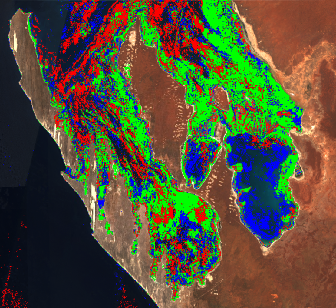
Instead of relying solely on localised field surveys, TONU is utilising advanced Earth Observation data to actively monitor coastal health. Built with Google Earth Engine (GEE) and Python, the Seagrass Sentinel utilises high-resolution optical imagery from satellites orbiting the Earth.
Here's a look behind the scenes at the science driving the tool:
Multi-Sensor Integration: The dashboard uses data from satellites such as Sentinel-2, which capture specific wavelengths of light reflected from the Earth's surface.
Geospatial Analysis: Healthy seagrass absorbs and reflects light differently compared to bare sand, deep water, or algae. By using specific spectral indices on satellite imagery, we can accurately identify and map the extent of the seagrass beds.
Machine Learning: The Sentinel employs advanced classification algorithms to quickly analyse large volumes of environmental data. This enables us to identify subtle ecological changes over time, turning complex raw data into a clear, actionable map.
Explore the Seagrass Sentinel
Our core mission at TONU is to bridge the gap between complex science and public education. We aim to make high-level remote sensing data accessible to everyone, from academic researchers and local conservation NGOs to curious beachgoers.
We have embedded the full, interactive dashboard right here on our website. You can zoom in on local coastlines, explore the spatial distribution of these habitats, and see firsthand how Earth Observation is driving modern marine conservation.
🌊 Click here to explore the Seagrass Sentinel live on our new interactive map! 🌊
As stewards of the planet, ensuring that vital environmental decisions are based on reliable, transparent data is our top responsibility. Check out the dashboard, explore your local coastal zones, and join us in advocating for the protection of our ocean's hidden meadows.